Dec 4, 2017
Land Surveying Has Gone High-Tech
The field of land surveying is rapidly changing and surveying companies must keep up-to-date with the latest tools and technologies. Going high-tech is the best way to deliver trustworthy results to decision-makers in land management, real estate, energy, forestry and agriculture. These project managers in business, industry and government need the best available information to plan, design, construct and maintain buildings, infrastructure and land development projects.
The Benefits of High-Tech
With pressure to do more with less, surveyors can no longer depend on only traditional survey tools to deliver their bread-and-butter service –precise and accurate information. They must also deploy high-tech survey tools and advanced technologies.
As a bonus to decision-makers, these new innovations save time and money in areas such as:
- Better design, drafting and construction documentation that improves communication and reduces surprises among client, design partners and subcontractors.
- Reducing project costs with precise planning and fewer change orders.
- Creating accurate scale MODELS and AS-BUILT drawings for better project planning in the future.

High-Tech Tools
The basics of land surveying will never change, but adding sophisticated equipment like 3D LASER SCANNERS and DRONES to the traditional toolbox takes the surveying profession to higher levels of service.
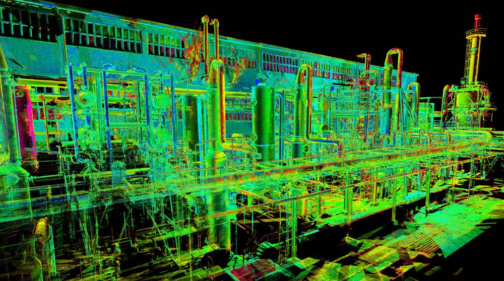
3D LASER SCANNERS
State-of-the-art survey equipment like the Faros 3D Scanner or Trimbles 3D Scanner can create a 3D virtual model of any object or place. Beams of laser light move around the entire surface, creating a digital point cloud of data on the computer. Leading-edge software later interprets this data to help clients in areas such as:
- Incorporating specific topographical elements into construction of new land developments.
- Scanning existing structures and laying out the identical footprint in a new facility.
- Creating 3D models of existing pipe infrastructure to fabricate new piping off-site.
- Assessing stockpile volumes for billing reconciliation.
DRONES
Drones, properly called unmanned aerial vehicles or UAVs, have become a standard tool for many land surveyors. They are used at all stages of survey projects in construction, energy, mining, agriculture, forestry and real estate. Whether the information need is for the planning, development or maintenance of a project, drones are impressive data collection devices that can do such things as:
- Fly over dangerous facilities, difficult terrain or remote locations.
- Take the aerial photographs needed to create GIS maps of a region.
- Use infrared to document the long-term impact of land development on a region such as from mining, logging or agriculture.
- Inspect the integrity of field infrastructure like pipeline networks.
- Take 2D or 3D images of construction sites at regular intervals to gauge progress.
Advanced Technologies
Along with using high-tech equipment is the need for interpreting the enormous quantities of data it generates. For this, advanced computing software is critical to making sense of the complex information with such applications as mapping software and GIS modeling.
MAPPING SOFTWARE
Point cloud data files created by the 3D LASER SCANNERS are analyzed by computer software like FARO SCENE or TRIMBLE REALWORKSand transformed into full-colour 3D virtual models.
Depending on the decision-maker’s information need, the data can be further processed with various other computer software programs like:
- AUTOCAD CIVIL 3D to create 3D virtual models of land surfaces, geotechnical profiles, grading elevations, gravity pipe networks, corridors, rail track layouts and more.
- REVIT, a Building Information Modeling (BIM) tool, to coordinate the work of all sub-trades involved in every stage of a building project, starting with the land survey.
- NAVISWORKS to integrate data from multiple sources to identify and resolve conflicts before construction begins.
GIS MODELING
A GEOGRAPHIC INFORMATION SYSTEM, OR GIS as it’s commonly called, is a powerful computer application that transforms geospatial data into visual models for easy analysis and decision-making. Geospatial data refers to any information with a physical location having latitude, longitude and elevation coordinates. Data may come from many surveying sources including aerial photographs taken by drones, ground penetrating radar, remote sensing, traditional surveys and mapping, and GPS.
GIS, part of a larger field of study called geomatics, is mainly used to make land development decisions. An energy company, for example, could use GIS to evaluate the best location for a new facility. GIS models can be used for other purposes such as:
- BOUNDARY, WELLSITE and WELLHEAD LOCATION surveys
- Detailed TOPOGRAPHIC MAPS of a region
- PHOTO MOSAICS, COMPOSITEmapping and orthophotography (aerial images adjusted for topographic relief, lens distortion and camera angles)
- VOLUME CUT AND FILL CALCULATIONS
- DEM (DIGITAL ELEVATION MODEL) CONVERSIONS
LN LAND DEVELOPMENT TECHNOLOGIES IS SKILLED IN HIGH-TECH SURVEYING
The surveying specialists at LN Land Development Technologies are skilled in not only traditional land surveying techniques but also high-tech specialty survey services such as 3D laser scanning, aerial surveys by drones, mapping, GIS modeling and more.
LN takes pride in being a skilled and progressive land survey and engineering company with in-depth knowledge of the industry’s most advanced equipment and software.
To learn how LN can support your project with quality information, email INFO@LNLDT.CA or call 780.488.9064.