Lakefront property - building your own home.

The housing market in Edmonton is holding its own despite the tough economic situation. Lower prices and less urgency mean it’s a great time for homeowners looking to purchase a new plot of land or build a custom home.

There are some important factors to keep in mind before that beautiful lake cottage or family dream home can become a reality. Get started on the right foot with this guide to basic land surveying considerations for a new build.
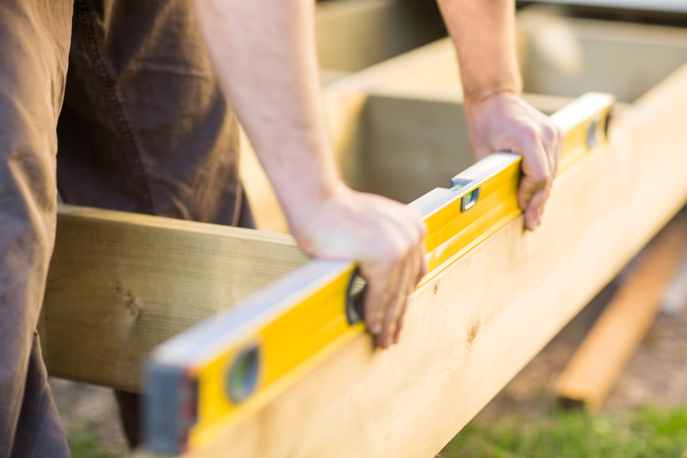
1. Lot Surveys

The best time to survey a piece of land is before you make an offer. If there are any problems or obstacles to building, a registered land surveyor could help you avoid a bad investment.

If you own a piece of land and would like to build on it, speaking to a certified land surveyor should be a priority. Not only will this help you determine your property lines (an essential part of homebuilding) but it will save you time when it comes to obtaining development permits.

Residential land surveys will determine:

From basic plot plans and boundary surveys to specialized construction surveys for heritage homes, LN has helped hundreds of Albertans take the first step in building their dream homes. Get in touch to find out how we can help you.

2. Lot Grading Certificates

Lot grading is an important part of home construction. The purpose of grading is to ensure proper draining away from a property, preventing flooding and water damage to your home.

Grading is especially important if your lot is situated on a hill or a slope, but all homeowners are responsible for ensuring their properties are property graded and maintained.

Obtaining a final grading certificate is a multi-step process that begins with a rough grading stakeout. LN can guide you through all parts of the process and offer competitive pricing on grading surveys as well as custom packages and bundled prices for new homeowners.

3. Home Placement

An initial residential land survey can also help determine the ideal position of the house on the building site, taking into account important placement factors such as the direction you would like the house to face, any restrictions on location due to local bylaws (such as how far back the property should be setback from the road), water flow, sunlight, and more.

Before you buy, consider that factors including lot orientation, lot space, and green space may also have an impact on the value of your home.

4. Lake Lots

When it comes to lakefront property, the home building process can become a bit more complicated.

In Alberta, a privately-owned plot of land will extend to the bank of a Crown lake (not the water’s edge) or it might extend only to a municipality-owned reserve.
Alberta Lake Management Law Graphic
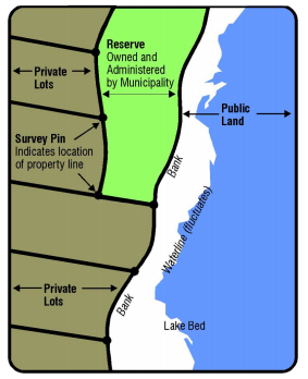
Image from the Alberta Lake Management Society, The Law and The Lake (PDF)

A land surveyor will be able to tell you exactly where your lakefront property begins and ends, and inform you of any building restrictions such as environmental protection or public access.

Remember that a lakefront lot might have additional surveying needs based on its likely location on a gradient.

5. Home Warranty

As of February 1st, 2014, every new home built in Alberta must be protected under warranty.

There are currently seven warranty providers that builders may partner with to provide this extensive coverage.

You can learn more about this process on the Home Warranty Alberta website. As a homeowner, you’ll be responsible for maintenance and upkeep.

What’s Next?

Building a home is a multi-step process, but it all starts with a good land survey.

Still in the dream stage? Browse this list of amazing property locations and let us know when you’re ready to go.

If you are ready to get started, we’d love to help. Request a quote, get in touch by email (info@lnldt.ca), or call us at 780.488.9064 to discuss your options.

Drones used for surveying

Drones, also known as unmanned aerial vehicles (UAVs) are no longer just the domain of Christmas presents, secret agents hijinks, or speedy Amazon deliveries.

For land surveyors, employing drones can save a lot of time and money. UAVs have the potential to transform the construction and energy sectors, so it pays to be up to date with the latest trends.

Trend 1: More Countries Approving The Use of Drones

Canada allows the use of UAVs for business as well as recreational purposes, leading to skyrocketing drone usage in many sectors. New regulations may come into effect in 2016, and any changes would be announced by Transport Canada.

The Federal Aviation Administration (FAA) has recently authorized the commercial operation of UAVs in the United States, a decision that allowed industry leaders British Petroleum (BP) to being using drones in earnest.

Trend 2: Smaller, Lighter Drones in the Oil & Gas Industries

BP first began to use drones for inspecting their extensive infrastructure of pipelines in Alaska in 2012, to accommodate for the difficult terrain and as a way to decrease safety risks.

But since the FAA ruling, drone technology is transforming the way they do business, allowing them to gain a competitive advantage as early adopters.

To inspect the existing pipeline structures, BP uses a simple quadcopter that cuts inspection time down dramatically. While there is a “pilot” on site with the drone, other engineers kilometers away can access information and images in real time. This allows them to address problems long before they become costly catastrophes.
BP is also using a true fixed-wing drone to scan and survey pipelines. While the drone is small – only 1.8m x 2m and weighing a mere 7 kilos – it can completely scan up to 2400 square miles from one point.

This is not only an efficient way to survey, but it decreases the chance of work-related accidents in the dangerous Arctic terrain. The UAV uses LIDAR (think of it as RADAR with lasers) to map the area, inspect field infrastructure, and even check on the safety of the hundreds of miles of roads that BP must maintain to manage their operations.

Smaller, lighter drones cost less to run and are easier to transport. With advanced materials like the ultra-light Kevlar becoming more readily available, drones are likely to keep shrinking in future.

Trend 3: Fully-Autonomous Drones in the Construction Industry

Another company that is using (and creating) drone and drone data technology is SkyCatch. One of their specialties is in the construction industry, where surveyors need to map data that may be changing on a nearly daily basis.

The new trend here is the “fully-autonomous” part. Unlike the BP drones, which use pilots on site, the Skycatch drone – also a quadcopter – is able to automatically determine its flight path, scan the job site, and land itself. Users simply program the site area from their Internet browser and launch the drone from the “black box” that serves as its hanger.

These drones are extremely useful in the construction industry because new 2D and 3D images of the entire site can be created every day. This allows for easy cross-referencing against earlier surveys of the site to compare project progression or change caused by natural events such as flooding, logging, or crop growth.

To see some great videos and more examples of drones being used in construction, architecture, and engineering, check out James Benham’s post from 2015.

Given their potential to even further increase efficiency and save time in the field, it’s likely we’ll be seeing more fully-autonomous drones in future.

Trend 4: Advances in Mapping and Modeling Software

All the drones in the world cannot help land surveyors if we aren’t able to understand the hundreds of images that they can take.

Happily, mapping software is improving alongside UAV technology, allowing users to create some truly astonishing models – like this 3D image of a castle generated by drone mapping software company PIX4D.

PIX4D offers a stand-alone software that integrates with the vast array of imaging technology on the market to produce a highly accurate image – the so-called “big picture”. The most amazing thing is that PIX4D can then render that image in true 3D in the virtual world. This allows users to view an entire site onscreen and understand exactly what steps may be necessary for development.

With mapping software progressing hand-in-hand with data collection by drones, understanding these technical programs (or working with someone who does!) is going to become increasingly important.

The Sky’s the Limit

Today, we’ve touched on 4 trends that we think are particularly important for land surveyors and the sectors we work with: approval and regulation of drone use in Canada and the US, the rise of smaller, lighter drones, fully-autonomous drones, and advances in modelling software.

Of course, the construction and oil and gas sectors aren’t the only industries benefitting from drones. From real estate, to mining, to agriculture, UAVs are becoming more and more important.

Engaging with this new technology in the surveying field offers us a fantastic way to add huge value to the people that we serve – answering questions and getting our job done faster and more efficiently than ever before.

If you’d like to find out more about drone technology, we’d love to chat with you. Request a quote, get in touch by email (info@lnldt.ca), or call us at 780.488.9064.

Fort-Mac-Fires

By now, everyone will have seen the devastating footage of forest fires ripping across Fort McMurray. The good news is that, so far, no life-threatening injuries or fatalities have been reported. Considering that pretty much everyone in Canada has colleagues, friends, and loved ones working in the area that kind of feels like a miracle.

Our hearts and thoughts are with those fleeing the city, and with Albertans and Canadians watching and waiting across the country.

Keep Updated

The CBC has a live blog and a list of resources for evacuees.

Whether or not you have a Twitter account, you can follow the hashtags #ymmfire and #ymmhelps for updated information.

How To Help

60,000 people have been evacuated from Fort Mac, and fuel shortages mean many are still stuck on the freeway or camping on the outskirts of the city.

Please donate if you can – text REDCROSS to 30333 to give $5 to Red Cross Alberta or donate online.

You can offer help (places to stay, pet care, etc.) through the Fort McMurray Evacuee Open Source Helppage, the Ft. McMurray Disaster Relief Page, or on Twitter.

Confirm You Are Safe

The members of our team in the Fort McMurray office have thankfully been confirmed safe (and some of them are staying at LN founder Lance Norman’s home).

Evacuated residents are asked to please email wildfire@rmwb.ca with your name, location and confirmation of safety.

The city of Edmonton has opened a reception centre for evacuees who need accommodation, and Facebook/Twitter are filling up with offers as more and more Canadians step up to help.

LN-crew-breakfast-after-ft-mac-fires

LN’s Fort McMurray crew eating breakfast at Lance’s house after their evacuation.

Get help from a surveyor to ensure you're making the right choices in your development.

You are gearing up for renovation season and you are pretty sure you know everything there is to know about your property. After all, you looked over that old survey in the paperwork when you bought the land. But do you really have all the facts?

You might – and in all honesty, that puts you a long way ahead of many homeowners. However, if you have any doubts, seeking the expertise of a professional surveyor will help you identify and solve common property issues before they become obstacles to that dream deck or kitchen extension.

Who Needs A Development Permit?

According to the City of Edmonton, anyone who wants to carry out construction, renovations, or changes to how a property is being used.

If you are building a new home, you will also need a building permit to prove that your structure complies with Alberta’s building code. If you are planning on extensive changes to your property, check out this step-by-step guide to the subdivision process.

When applying for a development permit, working with a surveyor or commissioning a real property report will make the whole process a lot smoother, and decrease the chances that your application will be rejected.

What To Consider Before Making Your Application

1. Property Lines

First things first – a survey is going to show you where the property lines really are, and possibly correct some bad assumptions.

It may seem obvious that a drain or utility line should be a boundary line, but years and years of development and old surveys can make the obvious obscure.

Knowing your property lines is essential for homeowners. After all, you don’t want to renovate or improve on any land that doesn’t actually belong to you!

2. Access and Right-of-Way

All physical access to public streets should be noted and, more importantly, any limitations to that access.

If, due to a low overhang, certain types of transportation could not reach the property, that would be noted. Think of those wonderful narrow streets in old European towns and then think of trying to maneuver a giant American SUV through them – it just wouldn’t work.

Your property may also have easements (also called rights-of-way) that limit your development options. For example, you may have an easement on the property for gas lines (meaning you can’t dig in a certain area) or a very old ruling granting permission to other individuals certain uses of the property.

The most critical piece of a survey may very well be in this research, since even if a right-of-way agreement was signed before you took ownership of the property you will still have to honor it and that could impede your intended development.

3. Obstacles Underground

It may be straightforward to locate obstacles above the ground, but in areas that have been developed for centuries, who knows what could be invisible underground? Surveyors can use historic data as well as sophisticated new technology to help you understand what lies beneath.

Of course, knowing the exact location of underground cables, pipes, or channels is critical before any excavation or construction begins. This ties in with the idea of easements, as utility companies may need access to your land. If surface water is noted, it may also be wise to have a clear understanding of the presence of underground water and how that could impact any development plans for the future.

You might even discover something rare like an old cemetery or burial ground – which could be very cool or very frustrating depending on how it affects your construction plans.

4. Environmental Concerns

Wetland alteration or other impacts on the environment must be carefully documented and obey local and regional bylaws.

Surveyors are experts when it comes to environmental site assessments and should be able to do a preliminary residential survey quite easily.

5. Zoning

Long before you get excited about a property for potential development, you need to know its zoning and restrictions.

The Zoning Bylaw provides guidelines for Edmonton’s zones, and you can find your property’s zoning designation using the City’s website.

It is worth noting that zoning regulations can differ dramatically across borders. A light industrial zone may give way to agriculture literally at a property line, and while the residents of one small town may be able to keep chickens in their backyard this might be restricted just blocks away.

6. Pre-Existing Issues

A land surveyor will also note any violations to existing codes.

Properties that have been unoccupied, or in which the previous ownership had not changed in many years, might be in violation of current codes. The new owner (i.e. you) would be responsible for correcting any issues before further development could take place.

In Summary

The permitting process can be lengthy and frustrating. Save yourself time and headaches down the road by working with a surveyor from the beginning to make sure your development proposal is in line with all requirements.

Oil and gas industry

Economic conditions in the Albertan oil fields aren’t great at the moment, making the work done by land surveyors even more important.

It’s obvious that if you don’t put a well in the right spot, you won’t get any oil. But not many people realize just how essential surveying and plotting infrastructure is for oil extraction.

There are four key ways that surveyors help make sure the patch stays profitable.

1. Data for Environmental Assessments

Given the importance of environmental regulations, Alberta’s land surveying companies are the “tip of the sword” when it comes to our oil industry.

All of the data collected by a surveying company is included in the approval process of the Alberta Energy Regulator (AER) and becomes part of a final wellsite survey plan.

This information allows the AER to understand and rule on the viability of the drilling process and any impact a well might have on the environment.

Considering that the AER rules on over 10,000 sites per year, land surveyors have a huge influence on this part of the industry.

2. Drones and Other Advanced Technologies

The implementation of new technology has allowed surveys to be completed faster and more cost-effectively.

Entire software suites are now dedicated to modeling environmental impacts, surveyors are able to use sophisticated technology including 3D laser scanning, and drones are taking to the skies.

As the technology has progressed, the amount of time it takes to survey even a large area has been dramatically reduced. In decades past, a truly thorough survey may have taken up to a month, but today, due to drone data and computers, that same survey could be done in less than a week.

Of course, this fantastic new tech doesn’t replace good old-fashioned human excellence. The engineers and surveyors who handle these processes very rarely make errors in relation to the wellsite survey plan. It comes down to experience, and these men and women have amassed an amazing skillset over their years in the field.

3. Future Proofing

Not only are surveys important for operational wells, but they provide a “savings account” of future profits that will pay out when the energy sector rebounds.

Although it may not be profitable to extract oil from a well this year, detailed surveys allow companies to plan for infrastructure costs and figure out exactly when a well will turn a profit.

If Company X knows that a given well will yield a certain number of barrels of crude, they can then extrapolate the costs of access, egress, equipment and permitting to know that oil prices on the open market need to be at, for example, $21 a barrel for the well to be profitable. Even if they don’t drill and begin to extract oil right now, they will be ready to go as soon as the price is right.

The surveying technology of today allows a precise understanding of the costs and benefits of doing business in the oil patch before the first piece of heavy equipment is even set up. It is turning potential oil-bearing properties into known investments that can be looked at as a savings account for the industry.

4. Home Grown Talent

Finally, Canadian surveyors are in high demand for their skills and Alberta has invested in an industry that brings money into the province from contract work across the country and beyond.

The Albertan Land Surveyors’ Association puts it best: “The oil industry cannot exist without land surveyors… If you put a well in the wrong place, no oilfield technology or amount of drilling will correct that.”

If you are thinking of a career in land surveying this is a great time to get on board. Our experience continues to drive business not only in the oil patch but also all over the world, even as we work through the current downturn in the energy sector.


This post tackles a pretty hard-hitting topic: that of workplace safety. Why focus on such a serious issue? Because if we work together we can help keep Canadians safe and healthy, and that’s something to be proud of.

Disregard for safety is one the four warning signs of a bad surveying company – and it is the only one that could be a matter of life or death. Today, three Canadians will die from a work-related injury, and one of these fatalities will most likely come from the construction industries.

Read on to find out how you can help keep employees free from harm by choosing a land surveying company that puts safety first.

How to Pick a Safe Surveying Company

Safety by the Numbers

Unfortunately, all companies are not created equal when it comes to safety.

In 2012 (the most recent available statistics), 977 workers were killed in their line of work and 22% of these deaths occurred in the construction industries. In the same year, over 27,000 work-related injuries were reported. – The Association of Workers’ Compensation Boards of Canada

The good news is that the Government of Canada and many companies across the country take this issue very seriously. Workplace injuries have decreased dramatically over the past decade, but there is still a long way to go.

You can make a difference by choosing to work with surveyors who employ the highest standards of health and safety. What does that look like? Find out below!

Best Practice

Safety isn’t just about offering the right personal protective equipment in the field. It is an attitude and a commitment that should permeate an organization from the very highest levels of management to the most junior contractors.

As outlined in the Royal Institute of Chartered Surveyors (RICS) safety booklet, an employer is responsible for the following:

• Providing information on health and safety

• Regular training

• Carrying out risk assessments

• Maintaining insurance

• Providing Personal Protective Equipment (PPE)

• Controlling working hours

• Having emergency procedures

At LN, we are proud to say that safety is our top priority. If you would like to ask us any questions about workplace safety, get in touch. We always have time to discuss this important issue.

It’s Easy To Do Your Part

Tight budgets and strict timelines are a normal part of life in the construction and energy sectors. The great news is that checking up on a company’s safety record isn’t difficult or time consuming.

• Overall, look for evidence of the requirements described above.

• A quick glance at a company’s website should tell you whether the organization emphasize safety. Do they proudly display their record?

• In Alberta, land surveyors should hold a Certificate of Recognition (COR) from the Construction Safety Association as proof of their commitment.

• You can check that a company follows through in the field by searching the new Alberta Occupational Health Database. This official record shows lost-time claims, disabling injury rates, and numbers of fatalities.

• Personal experience can be a good barometer for safety. Talk to a company’s past clients and ask for references that include health and safety.

Don’t be afraid to speak up if you feel any aspect of a job is unsafe. Not only is safety good for business, but you just might save a life.

Ready to Talk Safety?

Thank you for joining us in keeping Canadians safe, happy, and healthy at work.

LN has worked on thousands of projects in the energy, industrial, commercial, and residential sectors with zero fatalities and zero need for medical aid.

To find out more you can request a quote, get in touch by email, or call us at 780.488.9064.

If you are from Alberta, you probably remember the devastating floods of 2012 and 2013.

The purpose of lot grading is to protect your home and your neighbours’ homes from the flooding that can be caused by snow, storms, or run-off.

Not sure whether your home has passed a lot grading inspection? Read on to find out whether you need to obtain a final grading certificate.

What is Lot Grading?

Lot grading is an important part of home construction and refers to the creation of slopes and other features to ensure proper drainage away from a property.

There are two stages of Lot Grading Approval. Generally, the homebuilder assumes responsibility for Rough Grade (under the terms of the sales contract) and the homeowner completes the Final Grade approval.” – City of Edmonton

It is the homeowner’s responsibility to maintain the grading around his or her property. These City of Edmonton videos show cost-effective ways to keep your property safe from flooding.

Do You Need a Final Grading Certificate?

Lot Grading Certificates

The City of Edmonton requires lot grading certificates in order to complete their inspections and approve the final grading of homes.

These legal documents are created by registered land surveyors, and are provided as proof that there is no risk of drainage issues.

If you are ready to get started, LN offers grading certificates as part of our homeowner surveying packages. We are happy to offer advice so feel free to get in touch for a chat!

You can also check out this helpful and comprehensive guide to the approval process.

Rough vs Final Grading Certificates

In Edmonton, the Builder is responsible for obtaining a Rough Grading Certificate proving that a new home has been built in compliance with municipal bylaws.

After the Rough Grading Certificate has been granted, it is the responsibility of the homeowner to obtain a Final Grading Certificate within one year in order to prove that further landscaping has not interfered with the original grading.

It is possible to skip the Rough Grade Approval Process so long as the builder or property owner is satisfied that downspouts and other drainage systems are in place and working well.

So, Do You Need a Final Grading Certificate?

If any of the following three scenarios apply, then the answer is yes!

– You are the proud owner of brand new single family home (detached or semi-detached/duplex).

– You are redeveloping your property and want to regrade the lot.

– You are re-landscaping your property and plan to make major changes.

Remember: that amazing water feature or elevated flower bed may affect the slope of your lot and therefore your flooding risk. If you want to landscape your property, make sure you aren’t disturbing the original grade or seek approval in advance of any significant alterations.

Lot Grading Inspection

Once a homeowner has obtained the Final Grading Certificate from their land surveyor, they submit it to the City of Edmonton who will inspect the lot within 5 days.

If any changes need to be made these will be the responsibility of the homeowner, so you may want to hold off laying down sod or adding expensive final touches until approval is granted.

Ready to Get Started?

LN has helped hundreds of Albertan homeowners with residential surveys, final grade certificates, and lot grade design and management.

To find out how we can help you, request a quote, or call us at 780.488.9064.


Are you making the most of your surveying contractors?

It goes without saying that a good surveyor should complete your job on time, within budget, and without hidden costs. But there is a lot more they can do for you, especially when it comes to impressing clients.   

Below, Alberta-based land surveying company LN highlights four ways that working with a great surveyor will leave your clients feeling confident that you are organised, effective and on-the-ball.

4 Ways a Surveyor Can Make You Look Good to Your Clients

Better Budgets

Surveyors have access to–and are able to interpret–the latest information and data from the field. This means they are able to capture the exact quantities of material being used and predict what pay items will be needed in future, allowing them to generate precise budgets that reflect reality on the ground.

What’s the benefit for you?

Timely communication of exact costs allows for re-budgeting or reorganizing resources if necessary, and any problems will be flagged while there is still time to deal with them. It also means you can pass on up-to-date and accurate budget reports to your client over the course of a project.  

If you are ready to talk budget, LN offers free estimates and the team is always happy to have a chat at 780.488.9064.

Expertise and Support

Professional surveyors are field engineers with years of accumulated knowledge and experience. Whatever problems your project is facing, it is likely they have dealt with a similar situation in the past.  

The bottom line is that all projects will have their issues. We pride ourselves on coming into those situations, finding the root cause of the problem and providing our clients with the required information and support to come forward with solutions for their clients.”
Lance Norman, President, LN.

LN has no shortage of case studies across sectors. In one instance, a gross miscalculation meant a major Canadian mining company was flying blind at the planning stage of an important contract. LN stepped in to help the company re-budget and reorganize their resources, ensuring that the project remained profitable.    

Effective Meetings

A surveying company can provide professional drawings, reports, and site presentations for your client meetings, and will work with you to ensure the language and format are exactly right for your needs.

According to your preference, a surveyor could either equip you with all the knowledge that you need to present a project effectively, or a representative from the surveying company could attend clients meetings and answer questions in person.

Quality Assurance and Quality Control (QA/QC)

The reality is that anyone can make a mistake, and when it comes to large scale projects unexpected problems can be extremely costly and cause a domino-effect of progress roadblocks.

Working with an experienced surveyor will decrease the likelihood of slip-ups right from the get-go, and you’ll be better equipped to deal with the inevitable hitches of any job.

Quality assurance processes, the hallmark of a great surveying company, can be essential in finding (and solving) problems early on.  In fact, the cost of working with a surveyor can easily pay for itself in saved delays and costs of re-work.

Mike Lush, a project manager with LN, had found this to be the case on many occasions, not least during an international oil and gas project with a budget of nearly a billion dollars, the Hangingstone Expansion of the Japan Canada Oilsands site.

Find Out More

GET IN TOUCH BY EMAIL, call us at 780.488.9064 for a chat, or REQUEST A LAND SURVEY ESTIMATE to get started.

Before making any additions or changes to your home, it is important to make sure that the property you are improving actually belongs to you.

Thinking of Home Improvements? Why You Need to Know Your Property Lines

Beware of Assumptions

A fence or a hedge might currently separate you from your neighbours, but unfortunately these visual divisions often don’t line up with the legal boundaries of your property.

Invisible obstacles, like underground cables or drains, could also interfere with your plans for that extension or new sun room.

Finally, you might not be aware of easements or rights-of-way that give utility companies or other individuals the ability to access your land.

Avoid Worst Case Scenarios

Whether you accidentally encroach on your neighbour’s yard or realize too late that your land extends beyond your new fence, having to redo a building project will cost you time, money and likely cause some unnecessary headaches.

This is why it is worth investing in a professional survey before you get started on your home improvements. It’s also the best way to protect your investments for the future as it will be much more straightforward to sell your home if the property lines are clear and respected.

How to Find Your Property Lines

By far the easiest and most accurate way to determine boundary locations is to hire a professional land surveyor. This also protects your investment as any future disputes will be the responsibility of the company.

Depending on the kind of work you wish carry out on your property, there are a number of survey options available for residential homeowners.

Boundary surveys are typically used during the subdivision process, and pinpoint features such as underground pipes. A real property report (RPR) is a legal document that outlines property boundaries and is particularly useful for homeowners who want to check that proposed improvements comply with municipal requirements.

It is possible to find property lines on your own, and if you are interested in going down this route check out the Alberta Land Surveyor Association’s tips for locating property boundaries. You can also use historic land survey records, although there is an element of risk in using old surveys.

Reduce the Cost of your Land Survey

By doing your research in advance, you may be able to save your surveyor time, which can in turn save you money.

Getting Started

Ready to take the first step in home improvement?

LN has worked with homeowners in Alberta on thousands of successful property reports, and offers custom surveying solutions at great rates.

Request a quote, get in touch by email (INFO@LNLDT.CA), or call us at 780.488.9064 to discuss your options.

If you work in the oil and gas industry of Alberta, you know that hiring good quality contractors can be a challenge. Get the best results for your land surveying job by asking companies these three easy questions before you get started.

3 Questions to ask your Surveyor

1. Ask for a site presentation

Not only will a written presentation give you an insight into the professionalism and communication skills of the company, you can use it as a tool when reporting back to your team.
A good presentation will be customised and written in the most appropriate language for your needs, whether that means stripping away the jargon or covering every last detail. Site presentations are also a good investment because they can be recycled for other purposes, like drop-in sessions for local communities or meetings with your own clients.

2. Ask for references

Land surveying companies work with everyone from homeowners to huge industrial construction companies and they offer a number of services, not all of which will be relevant to your project.

You will need to ask what experience the surveyor has with clients who are similar to you.

The company should be able to demonstrate a positive track record by providing you with case studies from your sector. Here are some good examples.

Still feeling unsure? Call up one of the company’s clients and ask about their experience. If the surveyor is now one of their trusted contractors, that’s a great sign.

3. Ask who your Project Manager (PM) will be

A key component of quality assurance is clear, direct communication. The best way for companies to achieve this is by assigning clients a designated PM.

If you know your primary point of contact right from the beginning, the rest of the project will be much smoother.

Land surveys are often just one step in much larger-scale projects, meaning they are subject to strict timelines and budgets so they don’t hold up the rest of the work.

Good surveying companies understand this, and will have a step-by-step quality assurance system in place that allows you to see how your project is progressing against agreed targets. This will allow any problems to be dealt with well in advance of deadlines.

As discussed in a previous post on how to avoid hiring a bad surveying company, having clear quality assurance methods and a dedicated PM is absolutely vital to a successful project.

Need more advice?

Choosing the right land surveying company will make a huge difference to your project.

For more tips on how to start off on the right foot, check out this post on avoiding hidden costs from Lance Norman, President of LN.

If you would like some more information or just a friendly chat, get in touch by email (info@lnldt.ca), call us at 780.488.9064 or request a quote.

PRIVACY POLICY   |   © 2025 LNLDT. ALL RIGHTS RESERVED